In Bhutan, the most recent Glacial Lake Outburst Floods (GLOF) occurred with a partial burst of Lugge Tsho in Lunana on October 7, 1994. Some 18 million cubic meters of water rushed down the Pho Chhu, covering the 100-kilometer distance between the lake and Punakha in seven hours. It killed 21 people, damaged houses and property, and laid to waste 816 acres of dry land as well as 965 acres of pasture land.
Aside from the infrastructural damage, the loss of 21 lives itself should be an indicator of how severe a problem GLOF is.
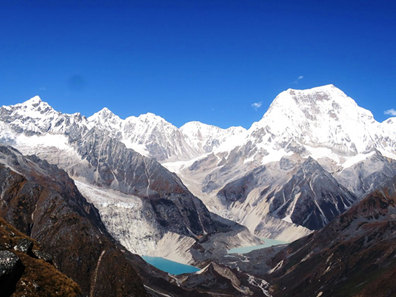
Satellite imagery has shown that there are 2,794 glacial lakes in the Bhutan Himalayas. Of these, 25 are considered to be potentially dangerous. The Pho Chhu basin with nine potentially dangerous lakes has been of particular concern to the Bhutanese government, especially in the Lunana area. This area is considered critical because it has four huge valley type glaciers – the Lugge, Thorthormi, Raphstreng and the Bechung, adjacent to each other.
The Thorthormi and Raphstreng pose the most immediate danger as the moraine separating the two is not only narrow, it is wearing down. Should it collapse and the waters of the Thorthormi overflow into the Raphstreng, the resulting GLOF is expected to be something around 53 million cubic meters. That is three times larger than the 1994 flood. And, because the ‘94 flood has already ‘cleared’ the path, such a flood will be faster and more destructive than any we have seen or recorded.
The Punakha Dzong, which has been partially damaged by GLOFs in 1957, 1960 and 1994, may not stand a chance then, in-spite of the river training works done along the Pho Chhu.

Following the alarm call of 1994, the obvious course of action has been to artificially lower the level of the lakes in Lunana. The criticality of the GLOF issue has attracted research and assistance from multiple parties including the Global Environment Facility, the World Wildlife Fund, the United Nations Development Program and the governments of India, Austria and Japan.
In the late 90s, an artificial outlet was made out of the Raphstreng to lower the level of the lake by five meters. Since 2008, similar work has been underway to lower Thorthormi by five meters. However, the task isn’t as simple as it sounds.
There is a window of only four months a year, June-September, during which the high passes into the area are not blocked by snow and ice. Then there is the challenge of working 4,350 meters above sea level, a nine-day walk away from the nearest motorable road. Just transporting rations for hundreds of people through high mountain passes is taxing enough.
There are three passes one has to cross. And at the work site, temperatures often drop way below freezing point. Every now and then, workers are known to be frostbitten to the point of having their limbs amputated. In the absence of heavy machinery, most of the work in the hostile environment is done manually. To give you an idea, last year, the plan was to lower the water level by more than a meter and a half. The workers managed to lower the level by only 86 centimeters. The route to the site was damaged by extremely bad weather and the project lost two months. So, with all these challenges, it is a steep uphill battle. Literally and otherwise.
Another aspect to Bhutan’s response to the threat of GLOFs has been to install an early warning system along the Pho Chhu sub-basin. High frequency (HF) wireless communication sets were installed at different locations. But even that has proved problematic because the HF sets are highly weather dependent and communication is impossible in times of bad weather.
Since 2002, however, people have been deputed at Thanza, where the water outlets from all four lakes meet. They are entrusted with monitoring the water level and ralaying this information to stations in Wangduephodrang, Dobani and Thimphu four times a day. Plans are underway to replace the existing system with a fully automated and more effective one, along with sensors in Lunana and the Pho Chhu tributary that will constantly relay information to different stations. The sensors will be part of a network most visible in the form of 10-14 siren towers set up along the Punakha–Wangduephodrang valley. The minute the sensors detect a dangerously high level of water, they will set off the sirens downstream giving people some time to evacuate and prepare for any eventuality.
As far as GLOFs is concerned, there is no permanent solution and the Bhutanese government is doing all that it can possible do to minimize damage in case of an outburst. The solution lies in the policies and practices of all governments and all peoples to combat global warming and climate change.
The temperature in the Himalayas is increasing by 0.06 degrees Celsius each year. Over the last 30 years, glaciers in the Bhutan Himalayas have been receding by 6.27 meters each year.